Commercial Corridors

Building District Brand, One Experience at a Time!

by Michele Reeves on January 31, 2018

Post image for Building District Brand, One Experience at a Time!

The Executive Director of the Historic Monterey Trail District, Nathan Ulsh, inspired me with a new tour he created for his South Sacramento corridor, so much so that I asked him if he wanted to guest post about it here! He does a great job bringing big picture resources to his district, and executing on the small things that foster connection and brand. Take it away Nathan…

=========================
Posted by Nathan Ulsh
=========================

How do you start to debunk the myth that your PBID’s commercial district is scary? This was the question I had when I observed that there were few white folks over the age of say, 40, meandering through our businesses on Franklin Blvd in South Sacramento.

Inspiration for tackling this problem came to me in the Spring of 2017: change minds one Spanish student at a time! I was perusing the Nextdoor app (social media platform similar to a virtual neighborhood watch) for Curtis Park, the neighborhood with a lot of disposable income directly adjacent to Franklin Blvd. They were recruiting students over 50 years of age for a level 102 Spanish class, and since it was drawing from Curtis Park and Hollywood Park, it meant this class was going to get good Anglo representation from consumers who might never otherwise go to South Sac.

Drawing on my experience conducting professional development tours for troubled youth to meet directly with business owners, I thought we could apply something similar for students in this Spanish class to foster more intimate conversations between Anglo customers and the amazing collection of multi-generational Latino-owned businesses that we have on Franklin Blvd. I reached out to the teacher, and offered a free business tour where her students could practice their Spanish, meet business owners, learn about Mexican culture, food, music and history, all while spending money in my district.

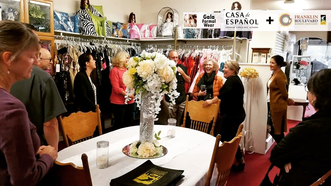
The teacher agreed and we were on. (Click on the image to the right to enlarge pix from our first tour!)

The best part of our Spanish meet and greet was the difference in attitudes before and after we set out. At the beginning of our outing, one of the attendees admitted that her friends had feared for her safety when she told them she was going on a business tour on Franklin Blvd. Thankfully she didn’t let it stop her!

We started with a brief history of our district, the vibrant culture represented here, and all of the projects we have in the works. Then we hit the road, on foot. Even though Franklin Blvd is an arterial, and consumers don’t think about walking, all of this was easily accessible as pedestrians.

Our first stop was Gala Formal Wear where my tour-goers learned about quinceñeras—the celebration, the attire, and the expense (these celebrations can easily top $10,000.) We asked everyone to come with an appetite, because the next port of call was a must-stop destination for the Mexican community: La Esperanza Bakery and Market. No one can resist their pan dulce (Mexican sweet bread), and our students chatted in Spanish about food and sweets, tasting a wide variety of specialties. The last stop of our two-hour tour was more food (it’s a good thing we were walking)! Los Inmortales provided a mouthwatering traditional Mexican dinner, and the owner conversed with our group in Spanish about his restaurant and the food that was served.

All in all, the business owners really enjoyed interacting with new customers, and the students ate it up (figuratively and literally).

At the end of our time on the street, the same woman whose friends had doubted her sanity for walking on Franklin Blvd said, “This was exciting! I am going to bring my girlfriends over to this area!” Everyone explained that they had not known about the history of the district, or the rich offerings of the businesses. It is, by far, the best collection of comments I have received about the district by outsiders. And now, they are going to tell every one of their friends.

And that’s how you change minds: one person at a time, having a great experience.

Needless to say, I am now offering quarterly Spanish-speaking business tours because it was so successful for everyone involved. (The folks cracking up above left are from our second tour.)

I love my job.

(Tour photos courtesy of Nathan Ulsh)

{ 0 comments }

A Wall, No Matter How Pretty, Is Still…a Wall

by Michele Reeves on March 11, 2014

Post image for A Wall, No Matter How Pretty, Is Still…a Wall

During the summer of 2013, my husband and I took a very uncharacteristic vacation to a spa in Scottsdale, Arizona. I say “uncharacteristic” because a spa in the desert at the height of summer would not normally be at the top of our list of vacation destinations.

But, long story short, we were quite happy to find ourselves, sans children, in this suburban Arizona town in June. (And, may I say, it was a lovely location from which to watch the super moon!)

So, one of the things that jumped out at me about The West’s Most Western Town (yes, that is Scottsdale’s somewhat official nickname), is that the built environment of this relatively new, arterial-focused city is dominated by walls.

Undulating walls…walls made of different materials…short walls, long walls, tall walls, grand walls, pony walls. There are walls with embedded art. There are elaborate walls along freeways. One special wall, my personal favorite, had fish sculptures on it that glowed a deep, blood red in the night.

And I realized something by the end of my stay there: no matter how much you spruce ’em up, a wall will always tell a story of division, of separation, of disconnection, of hinderance, and of restriction. They certainly lent an air of desolation while driving about the city, and made me rather desperate to penetrate the walls, so I could feel as if I had arrived somewhere.

wall1Wall5Wall10Wall2Wall3

wall4wall6Wall7Wall8Wall9

{ 2 comments }

Retail, REITs and Cannibalization

by Michele Reeves on May 4, 2012

Post image for Retail, REITs and Cannibalization

When he got his start in the grocery business with Fred Meyer decades ago, Gary Slabaugh said he knew EVERY property owner that surrounded the store where he worked. He knew them, their families, their kids’ birthdays. Part of managing the store was participating in, and being a member of, the surrounding community. Smart business if you are a retailer and property owner.

Fast forward a few decades, and contrast that with some of Gary’s more recent experiences as VP of Real Estate for Safeway, where he said some of their leased mall locations have been sold 12 times over the last few years. Each sale of the mall, he said, exchanged hands for more money, selling to another out-of-town Real Estate Investment Trust (REIT).

How did these properties increase in value if rent wasn’t increasing as well? We puzzled over this question as I was moderating a panel at the Portland ICSC Alliance event this year on the subject of Retrofitting Suburbia. (Keynote presentations by Michael Freedman and Ellen Dunham-Jones are available on the right hand navigation bar, if you follow the previous ICSC link.)

The role of retail and restaurants in a city is vitally important. Stores and eateries act as activators. They are entertainers. They are draws. They provide identity. Yet, few cities actually manage this square footage like the precious resource that it is.

In fact, as Gary’s story so beautifully illustrates, the whole nature of retail, particularly along arterials and in suburban communities, has dramatically changed, shifting almost entirely into the hands of institutional investors, out-of-state owners, and large corporations. Accountants are not retailers, as my professional crush Paco Underhill notes in Call of the Mall. (One of the reasons he cites for malls being so ugly!)

This consolidation of properties and development into the hands of absentee number crunchers has not been good for America’s communities. It has led us to us being an utterly and completely over-retailed nation, diluting the positive impact that retail and restaurants can have on our cities and towns. And, it has left us with under invested or abandoned retail infrastructure that drives down property values, invites crime, and creates negative identity, like the arterial pictured above left.

Let’s compare America’s retail spaces to the rest of the world.

In a Costar report from 2010, the real estate database and analytics firm estimated there is at least 56 square feet of retail space per person in the United States. This equates to about 46.6 square feet of total retail space per capita in our country, according to ICSC estimates.

Juxtapose those numbers with retail space in a few other countries. Canada and the UK clock in at around half of the US glut, and places like Mexico and India are closer to 2 square feet of retail space per capita. A fraction of the real estate we have enshrined to consumption!

What do these statistics tell us? The United States has more retail space than it needs…more than it can possibly use.

Every time a city adds retail space, it is cannibalizing its own existing retail infrastructure. This trend gets exacerbated in areas with sales tax, as cities duke it out over who lures Wal-Mart from the next county over.

In a reality where we have a huge oversupply of retail space, why do we keep pretending there are unlimited dollars just waiting to be spent? Why do we think that all we need to do is build the next new mall and everything will be great in our towns, neighborhoods and corridors?

Let’s look at a local example of this from Gresham, Oregon. (Click on the map below for images and more information.)

There is a fabulous little downtown here, that had, and still has, a great street grid, charming buildings, and a nearby park with a Japanese garden that is being renovated. As this suburban downtown started to suffer the inevitable postwar decline that occurred everywhere, what happened?

A strip mall was conceived and built right along the edge of downtown. (Mall #1 on the map.)

Did this help downtown? Of course not.

Since the strip mall was a super block, it ruined grid connectivity, it visually eliminated any connection between downtown and nearby streets, and the mall was oriented so its back faced downtown, doing the strip mall equivalent of mooning this once thriving center in Gresham.

Eventually, this “new” mall became dated. Downtown continued to suffer. So what happened next?

Another mall!! Across the street from Mall #1. Literally. This shopping paradise was larger, newer and lifestyle center-y. (Let’s call it: Mall #2.)

Sadly, with this much retail space stacked on top of each other, this is now an environment that struggles with vacancy and turnover. And, this massive amount of mall space is dwarfing a great downtown, and hindering its revitalization as well.

There are several big lessons for cities in all of this:

  1. Large corporations with no connection to your municipality often don’t care about your city, they are making decisions for their bottom line first and foremost. I would venture to say that nearly every REIT and big box concept has built in places that were clearly bad for the city and the surrounding area. Remember, what may be good for an out-of-town company is not necessarily good for a city as a whole.

  2. Complete, and keep up to date, a retail capacity assessment in your city.

  3. Don’t over zone for retail.

  4. Don’t allow new large retail developments without considering how they impact all retail infrastructure in the city.

  5. Give preference to local developers who have a stake in the community and tend to hold their properties for long periods of time. Real estate is rarely developed optimally, and maintained at its highest and best use for the whole community, if it is owned, controlled, and managed by institutional employees as an accounting exercise in another state.

Map image is courtesy of OpenStreetMap, © OpenStreetMap contributors, CC BY-SA

{ 1 comment }

A Tale of Two Hospitals: The Institutional Effect

by Michele Reeves on January 19, 2011

Post image for A Tale of Two Hospitals: The Institutional Effect

If an event center, or hospital, or college plunks down in your neighborhood, does it inevitably create a crater of blight and low property values? Or, is it possible to weave large institutions into the fabric of an urban community? Right here in Portland, two major in-city hospitals provide a stark contrast in success at integrating into their surroundings, giving us a great window into what works and what doesn’t.

Legacy Good Samaritan was founded in 1875 in Northwest Portland. Its roots were firmly planted in a pre-automobile era of urban planning when streetcars were king and pedestrianism was recognized as a viable form of transportation. And, luckily for the neighborhood, that history still shines through to this day.

In the modern era, the hospital has continued to adapt to its environment in two important ways. First, they have mirrored the character of the neighborhood with the choice of brick as a facade for their buildings. Second, as they have expanded into other buildings and parts of the neighborhood, the street grid structure has been maintained, with employees and patients using sky-bridges and city sidewalks to travel from place to place rather than vacating streets to build super block sites that would create a walled-off medical campus. The preservation of the grid has allowed the neighborhood to flow through the hospital structures instead of around them, which has led to this vast medical complex successfully being absorbed into the community instead of becoming a single-use crater in the center of it.

It is no accident that the successful absorption of Good Samaritan is directly linked to the fact that it is located in one of Portland’s most dense districts, which has been able to support its presence and still maintain a diversity of interests in the immediate surrounding neighborhood, including multifamily residential, retail, office, public school, religious, and medical uses.

This variety of uses coupled with the open grid also encourages this large medical institution to open up to the neighborhood. When a walled-off campus is created, the people within the campus are less likely to leave it and mingle with, and become a part of, the social fabric immediately outside their door.

However, to say that Good Samaritan has no negative impact on its surroundings would be an overstatement. Although NW 23d Ave, along which the hospital is located, is one of Portland’s strongest neighborhood commercial retail districts, it has developed more completely in the areas to the north and south of the hospital’s only super block site, shown in the photo to the left. As you can plainly see, this particular medical building was designed in such a way that it a) does not interact with the streetscape in the least, and b) it creates a two-block blank, which can be a death blow to a retail district, disturbing shopping continuity and becoming a border, beyond which visitors prefer not to venture.

Ideally, along this NW 23rd Ave frontage, Good Samaritan would have integrated active retail storefronts that could have contributed to a more intense street level experience, in character with the surrounding commercial buildings. It is no surprise that the buildings near the super block (pictured left) have been slow to renovate.

As a counterpoint to fairly successful integration, I offer you the Legacy Emanuel campus, pictured to the right, which is a prime example of an institution that has walled itself off after razing the surrounding neighborhood so that no trace of its original character remains. Founded in 1912, this medical center underwent major expansion in the 70s that dovetailed with other disastrous postwar urban renewal projects—specifically Memorial Coliseum and Interstate 5—that decimated the minority mixed-use commercial districts in the Albina neighborhood.

When driving south along N Vancouver Ave, as you near the hospital the entire feel on the one way couplet changes. You almost feel as if you could be in a suburban office park. Incredibly, the city’s largest trauma hospital is not even visible from the street. Only a sign informs you that you are in the vicinity of a medical facility. Instead of being lined with the streetcar-era mixed-use buildings and warehouses that are more typical of this area, near Legacy Emanuel, N Vancouver Ave is lined with parking structures that continue for blocks and blocks. True, they are nicely landscaped, but they act as a wall nonetheless. Pictured below are these barriers.

Behind the greened parking edifices sits the hospital. The physical impression that Legacy Emanuel is “other” is made loud and clear. It is a citadel of medicine that does not articulate or interact with the vestiges of the commercial and residential uses that still exist in the area. (Unfortunately, the stock of buildings that dotted this formerly vibrant district are long gone.)

Other problems in this area include a disconnected grid with one-way streets as well as the deep canyon that Interstate 5 creates to the west of the hospital, further reducing connectivity to other parts of the city. Additionally, Legacy Emanuel controls much of the undeveloped land surrounding the hospital, creating an even larger dead zone of surface parking and empty lots.

Essentially, they have successfully designed a single-use medical district that is, as a result, unsafe and unsightly. The hospital’s very presence impedes revitalization on its back doorstep, even though renewal is happening nearby on N Williams Ave, N Mississippi Ave and NE Martin Luther King Jr. Blvd.

The impact of this lack of diversity of use and functioning grid is keenly felt in Dawson City Park located across from the hospital, shown here. It is a public gathering place whose biggest constituents, on a per square foot basis, are a two-story low-rise office building with mirrored windows and a series of parking garages. It’s no wonder that its success as a public amenity is now mixed, at best.

This tale of two hospitals is an oft-told story that emerged from many city centers during the early days of urban renewal. The dense district with political clout staved off construction projects that would have destroyed the tight knit network of blocks, and in so doing, ultimately saved the neighborhood. The vibrant minority district, without the political clout, absorbed the full impact of nearly every large new public works project post World War II — Memorial Coliseum, Interstate 5, and the expansion of Legacy Emanuel Hospital.

{ 1 comment }